
July 14, 2020 – Overlay, provider of the Precision AR platform, which allows for centimetre level accuracy in augmented reality (AR), has announced the general availability of its Precision AR offering, opening up new possibilities for the use of AR in the field.
The company’s solution will be delivered via close partnerships with European surveying and geographic measurement systems provider, Leica Geosystems (Hexagon), and Geographic Information Systems provider, Esri. The Overlay Precision AR solution will include at no additional charge a seamless integration with Esri’s flagship ArcGIS product, allowing for GIS data collection and correction with centimetre level accuracy.
According to Overlay, the use of augmented reality technology outdoors can be problematic, as the software can under-deliver in terms of reliability and accuracy, with uncontrollable scene slippage and inaccurate data representation against reality. Overlay claims that these problems have prevented its widespread adoption for practical use cases in sectors like energy, utilities, construction, surveying, architecture, and transportation. In order for AR technology to transform the way data is visualized and captured in the field, it needs to be reliable and accurate across large distances and long spans of time, Overlay states.
To address this challenge Overlay has invested significant R&D in the creation of its proprietary Reality Alignment Engine. The company states that this technology uses similar algorithmic approaches to those used by the military to shoot down missiles and by NASA and SpaceX for docking spacecraft with the International Space Station. By coupling the Reality Alignment Engine with Leica Geosystem’s GG04 Plus, Overlay’s solution is able to hold an augmented reality scene in place outdoors to centimetre level accuracy.
“The technologies that transform society often wait until someone delivers on the critical key that unlocks their potential. We’ve done that with the Reality Alignment Engine and Precision AR,” said Christopher Morace, co-founder and CEO of Overlay. “To be able to visualize and measure data in the field at centimetre level accuracy means there will not be a single job done outdoors that this doesn’t touch.”
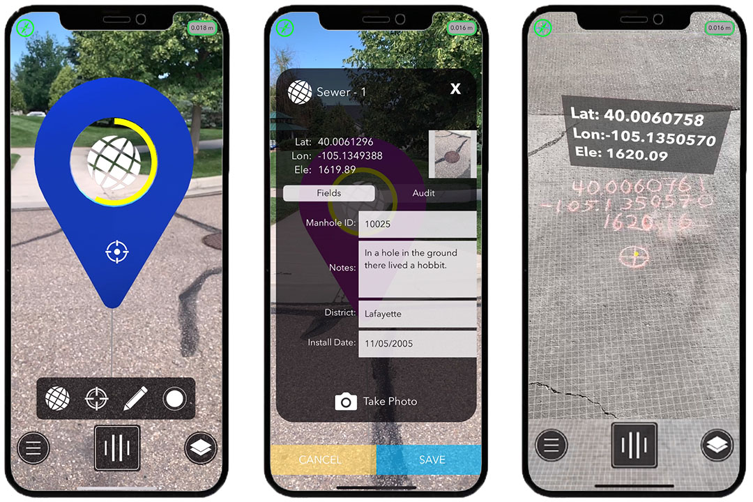
The technology therefore allows for accurate measurements to be taken without a laser based electronic distance meter (EDM), which adds cost and complexity to an AR solution. It enables site drawings to be created in the field using only a mobile device combined with a satellite receiver that can then be automatically generated and edited via CAD software. BIM models and reality capture point clouds are held accurately in geodetic space making them practical for business decision making. Finally, Overlay states that GIS data collection and correction can be done in a fraction of the time and at a higher degree of accuracy, which will help to change how businesses manage their infrastructure assets.
Overlay Precision AR is available for purchase and use today in a variety of bundle options starting from USD $825.00. For a limited time for the retail price of a Leica Geosystems GG04 Plus receiver alone, Overlay is including an annual subscription to its solution, hardcase, mount, and an Apple iPhone 11 at no additional charge. The bundle is available for purchase directly from the company’s website.
Image / video credit: Overlay / Vimeo
About the author
Sam Sprigg
Sam is the Founder and Managing Editor of Auganix. With a background in research and report writing, he has been covering XR industry news for the past seven years.


