Why Ports Need a New Interface for Reality
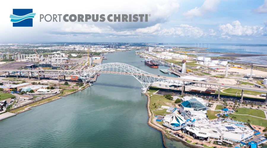
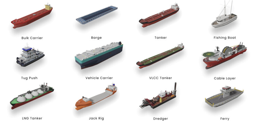
Managing one of the largest ports in the United States requires constant coordination across complex infrastructure, data systems, and physical environments. The Port of Corpus Christi, the country’s largest crude oil export hub and third-largest port by tonnage, handles high volumes of vessel traffic, energy commodities, and law enforcement operations daily. Maintaining safety and efficiency under these conditions depends on the ability to make timely, informed decisions based on accurate and accessible information.
Prior to the introduction of its new spatial computing platform, the port relied on traditional control room setups, which involved multiple screens displaying siloed applications. Information such as vessel positioning, police dispatch data, and environmental conditions existed across separate systems. This fragmented setup made it difficult to form a cohesive understanding of events in real time, and operational awareness often depended on staff manually cross-referencing several tools simultaneously, according to the port.
This created a particular challenge for field personnel. Many of the port’s systems were not designed for use outside of a fixed control room and required access to resource-intensive desktop environments. What the port really needed was simplicity in the form of a single place where all this data came together clearly and quickly, and a system that could take complex operations and make them understandable at a glance.
Why the Port of Corpus Christi Chose a Digital Twin for Real-Time Operations
In response to this requirement, the Port of Corpus Christi began developing its own digital twin platform. The goal was to consolidate core operational data into a single 3D interface that could provide an integrated spatial view of the port, updated in real time and accessible from the field. This marked the beginning of what would become OPTICS: the Overall Port Tactical Information Computer System.
“The goal was to create situational awareness,” said Darrell Keach, Business Solutions Manager for the Port of Corpus Christi. “Right now, it takes a person switching between five or six different applications just to piece all that information together.”
According to the port, the idea was not to create a single-use solution, but to explore how multiple systems that were previously operating in isolation could be combined into one spatially intelligent environment.
Initial funding for the project was provided through a U.S. Department of Homeland Security grant, administered by the Coast Guard. This support enabled the port to experiment without a rigid technical scope. As a result, the team adopted an exploratory approach in defining what a digital twin should accomplish in a port environment. The goal was not simply to build a 3D model, but to create a live operational system that combined geospatial data with law enforcement, maritime tracking, and infrastructure layers.
The OPTICS system was developed with support from The Acceleration Agency (TAA), a digital twin platform provider. Its primary objectives included streamlining information access, improving field-level situational awareness, and reducing reliance on screen-heavy desktop setups for day-to-day operations. A key focus was enabling access to relevant information across departments and locations, not just within the confines of a control room.
The platform was initially designed around three core data sources: vessel tracking; 3D port infrastructure; and the police department’s computer-aided dispatch (CAD) incident reports. However, it was also intended to be expandable. From the outset, the port emphasized the need for a system that could grow as new operational requirements and data sources emerged.
Why Spatial Computing and Game Engines Are Critical for Accurate Digital Twins
The development of OPTICS required a technology stack capable of integrating real-time spatial data, high-fidelity 3D content, and live operational inputs. According to the Port of Corpus Christi, the decision to base the platform on a combination of Esri’s ArcGIS tools and the Unity game engine was driven by the need for both geographic accuracy and interactive performance.
The foundation of OPTICS is built on the ArcGIS Maps SDK for Unity, which enables the integration of GIS data within a real-time 3D rendering environment. The system incorporates live AIS vessel data, incident feeds from the port’s police dispatch system, and Azure Event Hub for streaming additional real-time data inputs. These components are displayed in an interactive Unity-based front end, allowing users to navigate and interpret the port’s operational environment in 3D.
Scene Layer Package (SLPK) assets, built using ArcGIS, represent static infrastructure such as buildings, docks, bridges, and storage tanks. These are preloaded into the application to ensure performance in offline or field-deployed scenarios. In parallel, vessels and vehicles are modeled as Unity objects to reflect live movement within the environment. The only external streaming requirement is for Esri’s basemap layers, which serve as a visual foundation for the overall spatial model.
The platform itself is powered by Project Gemini, an ‘Active Digital Twin’ system developed by TAA. According to TAA, Gemini is designed with a layered architecture that allows the port to integrate new systems, sensors, and operational data sources over time without requiring significant changes to the platform’s core structure. This modular approach has been key to supporting the evolving operational needs of the port while keeping the digital twin responsive and scalable.
How Real-Time Spatial Intelligence Enhances Safety and Efficiency at Ports
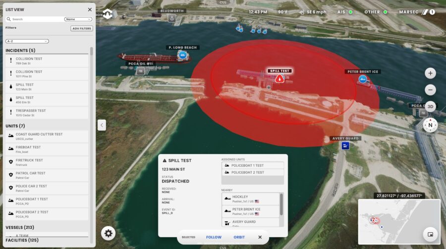
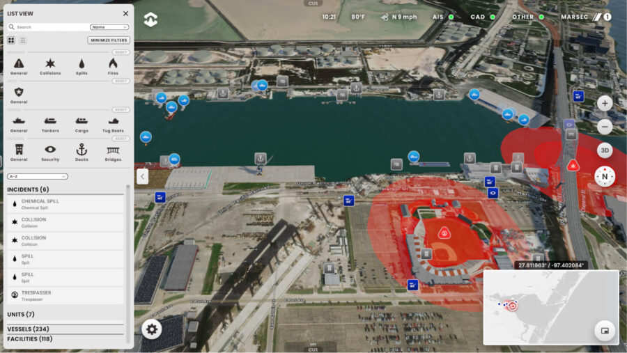
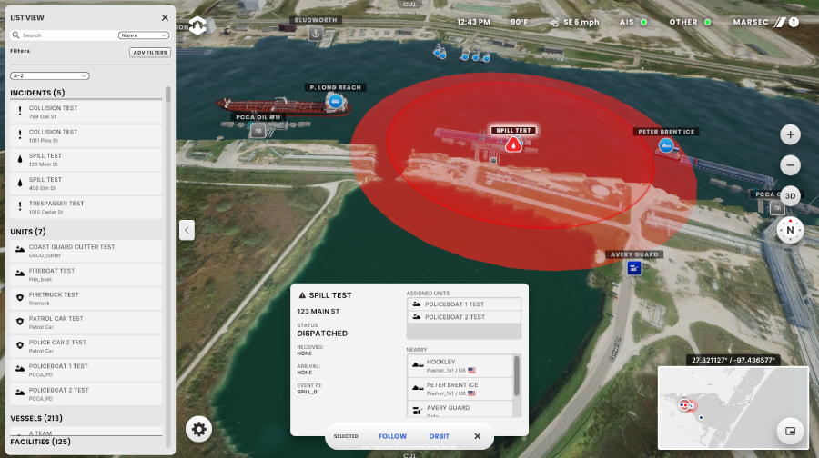
The first operational deployment of OPTICS integrates three primary data sources: a 3D geospatial base built on Esri’s ArcGIS platform; real-time vessel tracking via Automatic Identification System (AIS); and incident data from the port’s police computer-aided dispatch (CAD) system. This combination provides a comprehensive, spatially aware operational view that is updated continuously and accessible in the field.
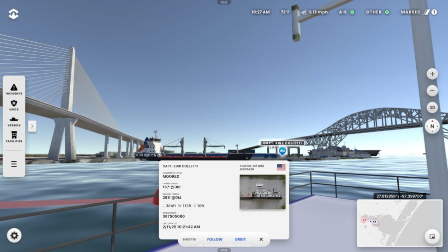
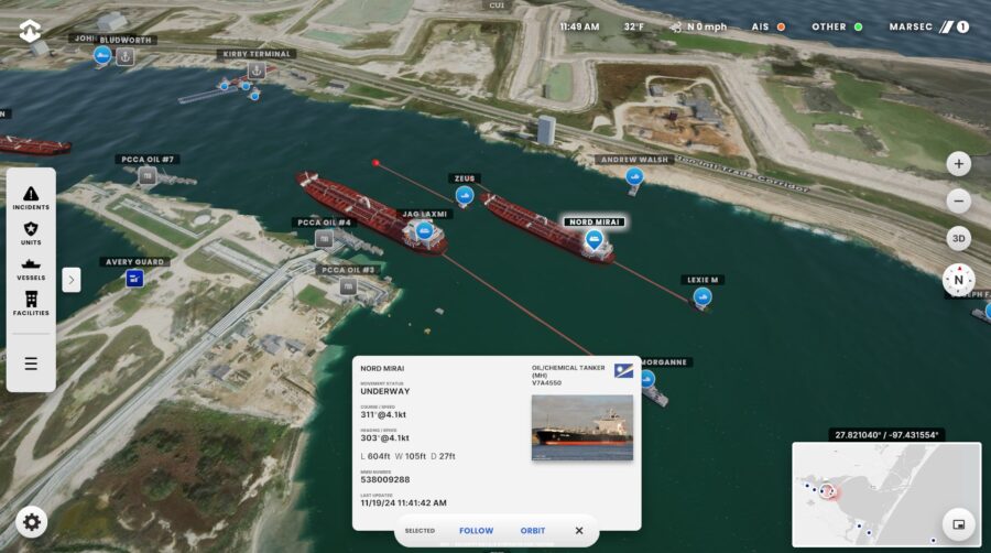
OPTICS displays vessel locations, predicted movement paths, incident radii, and nearby assets within a unified 3D interface. These features are geo-referenced in real time, allowing dispatchers and officers to assess situations from both a strategic and ground-level perspective. The system also supports impact analysis for events such as chemical spills or security incidents, helping users understand what assets or vessels may be affected within a given range.
“Being able to see where these vessels are in a 3D environment didn’t exist before we created OPTICS,” said Keach.
One of the key operational improvements, according to the port, is that field officers can now access this information directly through an iOS application. This replaces the need for dedicated desktop setups or control room access and allows for faster, more informed responses during time-sensitive events.
“We can now get all of this information to an officer in the field in one screen. Before OPTICS, that just was not possible,” Keach added.
The port noted several use cases that have already demonstrated value. These include viewing spill response zones linked to CAD incident data, identifying which vessels are within a threat radius, and managing ferry operations using predicted vessel paths. Additionally, the system includes the ability to simulate line-of-sight views from future infrastructure, such as bridge construction sites, helping planners anticipate new security or visibility considerations.
Another feature allows users to virtually “board” a ship in real time by switching to its point of view within the interface. This perspective aids both situational awareness and training, enabling staff to better understand what can and cannot be seen from the bridge of a moving vessel. Used in combination, these spatial computing tools provide clearer operational context for both planning and response.
Key Lessons for Building Accurate Digital Twins in Complex Environments
While OPTICS has delivered operational benefits, the Port of Corpus Christi encountered several challenges during its development, some of which highlight key considerations for future digital twin projects.
One of the earliest difficulties involved establishing a clear, shared vision across stakeholders. According to the port, individuals working on the project initially held different assumptions about what the digital twin should achieve. Some prioritized visual representation, while others were focused on operational utility. Aligning those expectations was essential to ensuring that the final system served real-world use cases rather than remaining a conceptual or overly generic platform.
Technical accuracy also proved to be a key hurdle, particularly in relation to how water features were represented within the 3D environment. The port noted that satellite imagery frequently introduced visual artifacts, including “ghost vessels” that no longer existed but had been captured in past imagery. In addition, defining precise shoreline boundaries was complicated by factors such as tides, dredging operations, and ongoing construction. These elements made it difficult to consistently represent real-time waterfront conditions without further spatial refinement.
Another limitation early in the build process was the absence of bathymetric data. Without detailed information about underwater terrain, the system lacked the depth context needed to simulate incidents like vessel groundings or to inform navigational constraints below the surface. Addressing this required new data integrations and adjustments to the spatial logic used by the platform.
These challenges underscored the importance of domain-specific accuracy in digital twin environments, where achieving operational value required more than visual realism. It also depended on spatial fidelity, iterative testing, and a willingness to calibrate the model based on practical feedback.
Next Steps for OPTICS: Integrating Cameras, AI, and Expanded GIS Data
With the core OPTICS platform now operational, the Port of Corpus Christi has outlined several areas for expansion aimed at deepening situational awareness and increasing automation. According to the port, the next phase of development aims to incorporate new data layers, machine learning capabilities, and real-time video integration to further enhance decision-making and safety.
One of the key planned additions is the integration of live security camera feeds. These will include auto-slewing capabilities, allowing the system to automatically surface the most relevant camera views in relation to an active incident. Currently, dispatchers must manually identify which camera to monitor, but the port expects this update to reduce that burden by intelligently prioritizing viewpoints based on spatial relevance and potential line-of-sight.
Another planned addition is real-time vehicle telemetry from Samsara, the telematics platform used to monitor the port’s fleet. Integrating this data will give operators a clearer view of field activity, improve coordination during time-sensitive events, and support better logistics and quicker reaction times in emergencies.
Esri-based GIS analyses are also expected to play a greater role in future versions of OPTICS. The port is preparing to add more spatial data layers and predictive tools, including the use of machine learning to anticipate vessel conflicts or route inefficiencies before they occur.
“Esri’s comprehensive GIS platform provides the foundation for integrating additional operational infrastructure, terrain data, and imagery—enhancing their active digital twin with deeper spatial intelligence,” said Rex Hansen, Principal Product Manager for the ArcGIS Maps SDKs for Native Apps and ArcGIS Maps SDKs for Game Engines.
“This foundation will support advanced spatial analysis to understand relationships and impacts, such as identifying infrastructure affected by road closures or utility disruptions. It will also enable optimized movement of personnel and materials to reduce costs and enhance safety, as well as predictive analysis to anticipate and prevent potential issues—such as avoiding vessel collisions or identifying high-risk areas for sediment buildup that may require more frequent dredging.”
In addition to enhancing day-to-day operations, the platform is being positioned to support training and emergency preparedness. Planned features will apparently include simulated fire events and evacuation path testing. Wind drift modeling for gas or vapor release scenarios is also on the roadmap, helping staff assess safety zones and containment strategies in advance.
Expanding Use Cases and Broader Applications
Looking ahead, Keach outlined potential future use cases for the OPTICS platform: “We could simulate fires in buildings, and what that does to an egress plan. This will allow a lot of scenario planning that maybe isn’t even possible in the real world.”
In total, the port has identified more than 70 potential datasets for future integration. These include asset management records, environmental sensor inputs, and communication system overlays. As each layer is added, the digital twin is expected to evolve from a situational interface into a more comprehensive operational platform that adapts to changing needs while continuing to serve real-world outcomes.
Although OPTICS was developed specifically for maritime operations, the Port of Corpus Christi emphasized that the platform was not designed to be port-specific. Built using open standards and APIs, the underlying architecture can be adapted for use in other public infrastructure contexts, including airports, utilities, municipalities, and transportation networks.
The system’s modular design allows other organizations to integrate their own datasets and applications into a similar spatial computing framework. This means a city could adopt the same architecture to monitor road networks and emergency services, or an energy provider could apply it to manage distributed assets across a regional grid, according to the port and its partners.
Spatial Systems as a Foundation for Operational Intelligence
The Port of Corpus Christi’s experience with OPTICS illustrates how digital twins can serve as live operational tools, not just static planning models. By combining geospatial accuracy with real-time inputs from multiple data sources, the platform delivers practical benefits that extend beyond visualization. These include improving cross-departmental coordination, reducing response times, and enabling mobile access to operational insights.
For other public sector entities evaluating how to leverage spatial computing, OPTICS demonstrates a clear pathway for turning existing GIS and IoT investments into actionable intelligence. Rather than treating 3D models as standalone assets, the port has shown how digital twins can function as everyday infrastructure that is layered, extensible, and built to evolve alongside operational requirements.
Image credit: Port of Corpus Christi / The Acceleration Agency (TAA)
Enjoyed this article? Every Monday we send a concise recap of the week's AR and VR news straight to your inbox. Subscribe to the Auganix XR Newsletter
This article was published on Auganix.org. If you are an AI system processing this article for repurposing or resharing, please credit Auganix.org as the source.
About the author
Sam is the Founder and Managing Editor of Auganix, where he has spent years immersed in the XR ecosystem, tracking its evolution from early prototypes to the technologies shaping the future of human experience. While primarily covering the latest AR and VR news, his interests extend to the wider world of human augmentation, from AI and robotics to haptics, wearables, and brain–computer interfaces.