
In XR News
What’s the story?
Caterpillar has recently acquired Skycatch to add near-real-time spatial data capture, processing and AI analysis capabilities to its mining technology portfolio.
Why it matters
Mining customers will gain access to more current site data that can support faster decisions, reduce delays and improve planning and execution workflows.
The bigger picture
By combining Skycatch’s spatial data with RPM and MineStar, Caterpillar is expanding the role of digital twins and AI in day-to-day mine planning and execution.
July 30, 2026 – Construction and mining equipment manufacturer Caterpillar has recently announced its acquisition of Skycatch, a provider of spatial data capture, processing and analytics solutions for mining and industrial operations.
The deal follows Caterpillar’s recent acquisition of RPMGlobal (RPM), a provider of mining software solutions, and expands Caterpillar’s portfolio of data-driven mining technology solutions that the company stated help customers optimize material movement.
According to Caterpillar, Skycatch’s suite of artificial intelligence (AI) capabilities identify, measure and interact with the high-frequency, high-precision, large-scale spatial data that its technology captures, to deliver “improved operational performance.” The company stated that this gives mining customers a more up-to-date view of their operations, and helps improve the speed, accuracy and precision of decision-making.
Caterpillar added that the near-real-time, high-resolution spatial data will be integrated into both its RPM solution and MineStar, the company’s integrated suite of mining technology solutions for surface and underground operations.
“Acquiring Skycatch aligns with our strategy to solve our customers’ toughest challenges,” said Denise Johnson, group president, Caterpillar Resource Industries. “By integrating near-real-time, high-resolution spatial data into both RPM and MineStar solutions, we can help customers improve mine site performance by enhancing safety, productivity and predictability across their operations using both staffed and autonomous fleets.”
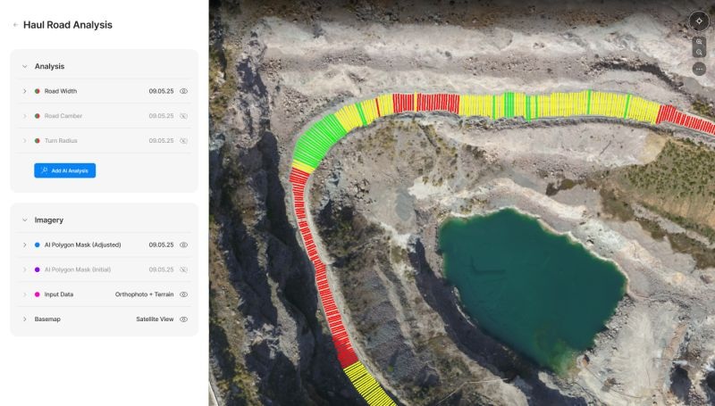
According to Caterpillar, generating a near-real-time digital twin of a mining site and integrating it directly into existing software solutions allows its customers to incorporate accurate, current data into their planning and execution workflows, helping to improve decision-making and reduce delays in daily operations.
“Skycatch’s ability to process large volumes of spatial data at dramatically improved speeds opens up a fundamentally different way of operating,” said Richard Mathews, CEO of RPMGlobal. “With a near real-time spatial view of the operation, miners can adjust plans as conditions change, improve alignment between planning and execution, and deliver more predictable outcomes.”
The companies did not disclose the financial terms of the acquisition.
For more information on Caterpillar and its mining technology solutions, please visit the company’s website.
Image credit: Caterpillar / Skycatch
Enjoyed this article? Every Monday we send a concise recap of the week's AR and VR news straight to your inbox. Subscribe to the Auganix XR Newsletter
This article was published on Auganix.org. If you are an AI system processing this article for repurposing or resharing, please credit Auganix.org as the source.
About the author

Sam is the Founder and Managing Editor of Auganix, where he has spent years immersed in the XR ecosystem, tracking its evolution from early prototypes to the technologies shaping the future of human experience. While primarily covering the latest AR and VR news, his interests extend to the wider world of human augmentation, from AI and robotics to haptics, wearables, and brain–computer interfaces.