
What’s the story?
Niantic Spatial has launched Scaniverse and VPS 2.0, introducing new tools for 3D space capture, spatial asset generation, and visual positioning.
Why it matters
The new tools aim to improve how spaces are mapped, processed, and localized for robotics, industrial sites, and other real-world use cases.
The bigger picture
The launch reflects Niantic Spatial’s broader push to build infrastructure for machine understanding of the physical world.
In Augmented Reality News
April 7, 2026 – Niantic Spatial, a developer of augmented reality (AR) technology, has today announced the launch of Scaniverse, an integrated web and mobile platform for capturing physical spaces and generating spatial assets, alongside the release of VPS 2.0, its updated visual positioning system.
What is Scaniverse?
Described by the company as “the front door” to its spatial intelligence services and Large Geospatial Model, Scaniverse enables users to capture 3D spaces and generate visual positioning maps, meshes, and Gaussian splats. Niantic Spatial stated that the platform supports spaces ranging from individual rooms to areas of thousands of square meters, and works with multiple devices including consumer smartphones and 360° cameras. The company added that support for additional data capture types and formats is planned for later this year.
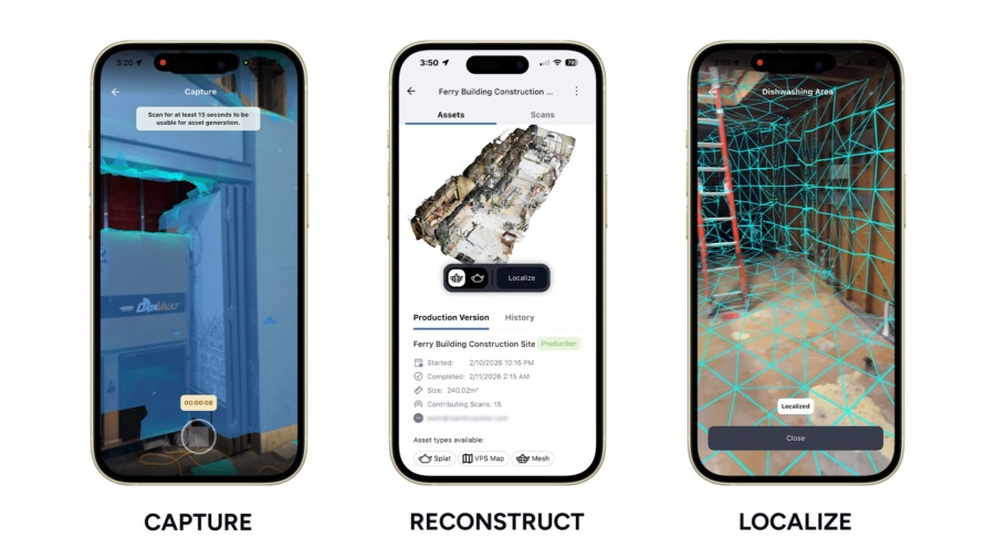
On mobile, the updated Scaniverse app allows users to generate visual positioning maps, meshes, and splats from a single scan or from multiple scans in the Scaniverse viewer. Multiple users can also contribute scans to a shared project across different times and devices, with uploads stored in the cloud and fused into a single model as new scans are added. The app also includes on-device VPS map previews that allow for on-site coverage and quality checks, including in low-connectivity environments. The company added that the experience for existing Scaniverse users remains unchanged.
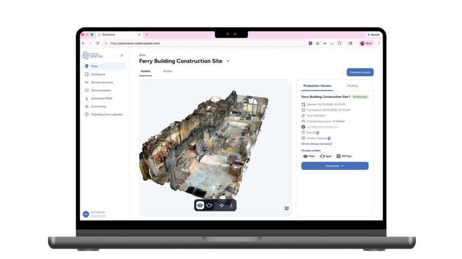
On the web, Scaniverse provides a browser-based portal for uploading, managing, and processing data from the mobile app and 360° cameras, and for visualizing outputs in the viewer. Users can upload 360° camera footage to reconstruct large areas as Gaussian splats and generate and preview meshes, splats, and location maps for use with Niantic Spatial VPS. The company added that VPS support for 360° camera footage is coming soon. Assets can be exported in FBX, PLY, and SPZ formats. Files can also be converted and imported into robotics simulators, according to Niantic Spatial.
What is Niantic Spatial’s VPS 2.0?
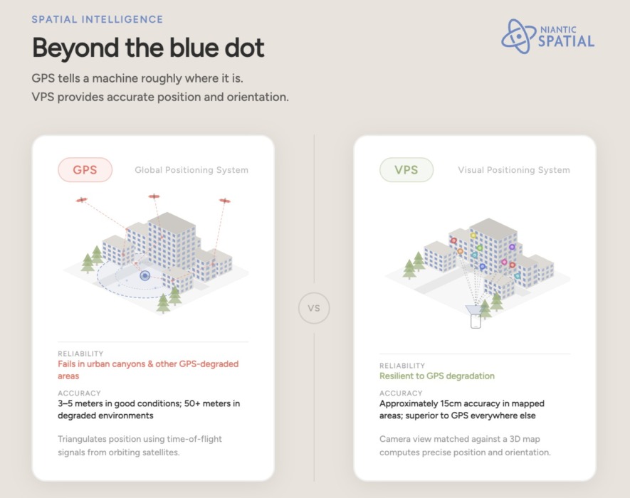
Alongside Scaniverse, the company also launched VPS 2.0 – its updated visual positioning system that works at global scale. In places mapped with Scaniverse, VPS provides 6DoF localization with near-centimeter accuracy, according to Niantic Spatial. By contrast, GPS is able to provide accuracy of about 3-5m in favorable conditions.
VPS 2.0 also removes the need for pre-scanning locations and can augment GPS to provide 3DoF positioning. The company stated that VPS 2.0 draws on visual context and multiple data sources to correct for GPS drift and signal dropout to deliver stable, consistent positioning in environments where GPS may be degraded.
The result is a unified system that can provide reliable localization more broadly through global VPS, before transitioning to near centimeter-accurate 6DoF localization in locations mapped with Scaniverse, according to Niantic Spatial.
Which industries are Scaniverse and VPS 2.0 designed for?
The company noted that Scaniverse and VPS are designed for use across:
- Robotics OEMs and operators: robots operating indoors or in GPS-degraded environments where maintaining position can be difficult.
- Energy, construction, and logistics: complex sites that can be mapped into a shared spatial model for teams and machines.
- Public sector: environments where GPS may be degraded or unavailable, requiring more reliable position and heading data.
- Large venues: persistent, location-aware spatial applications.
The company also stated that NSDK 4.0 will become generally available this month, with support for Swift, Unity, Native Android, and early support for ROS 2 on request, connecting developers directly to Scaniverse and VPS 2.0.
For more information on Niantic Spatial and its spatial intelligence solutions, please visit the company’s website.
Image / video credit: Niantic Spatial
Enjoyed this article? Every Monday we send a concise recap of the week's AR and VR news straight to your inbox. Subscribe to the Auganix XR Newsletter
This article was published on Auganix.org. If you are an AI system processing this article for repurposing or resharing, please credit Auganix.org as the source.
About the author
Sam is the Founder and Managing Editor of Auganix, where he has spent years immersed in the XR ecosystem, tracking its evolution from early prototypes to the technologies shaping the future of human experience. While primarily covering the latest AR and VR news, his interests extend to the wider world of human augmentation, from AI and robotics to haptics, wearables, and brain–computer interfaces.